http://www.wiu.edu/users/cre111/older/CGFinal/paper.htm
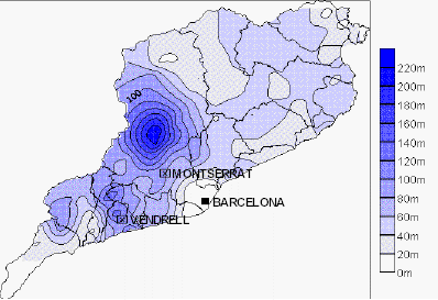
Cartographic Animation Maps are used to show the change over a period of time in certain areas of the word, and have become increasingly more popular throughout the years. This particular cartographic animation map was used in order to display realization results and visualizing spacial data. The graph shows the most optimal paths that came to be from the results, as it was impossible to display 250 potential paths one could take to traverse this specific terrain.
Tuesday, April 3, 2012
Isopach Map: Southern England and English Channel: Purbeck Formation
http://www.southampton.ac.uk/~imw/Durlston-Bay-Lower-Purbeck.htm#headpage
An Isopach Map is a map that depicts the various thicknesses within a single stratum. The term Isopach refers to the actual contour line that joins together areas of equal thickness. This particular map is of the Purbeck Formation in Southern England and the English Channel. This formation, thought interesting from a geological, should not be taken as just a natural phenomenon which we wish to explore. The map shows the variety in thickness of the rocks and cliffs surrounding the bay and is used to warn those who wish to live on the unsteady cliffs or traverse the sound of the dangers of such unsteady and diverse geological regions.
Isohyet Map of Seasonal Precipitation: Burkina Faso, 1992
http://www.tidsskrift.dk/visning.jsp?markup=&print=no&id=72903
Another type of weather map, an Isohyet Map portrays the average precipitation of a given geographical location (region) through the use of isohyet lines, or lines that connect points of equal precipitation on a map. This particular map shows the seasonal precipitation of Burkina Faso in 1992. The map is very basic, and points only the 138 rainfall stations, as well as the 'ground truth location.' This map is used in a paper that discusses the correlation between the areas with most rainfall and the areas with the most vegetation.
American Isotach Windmap
http://stresscretegroup.com/technical-resources/wind-maps/american-isotach-wind-map.asp
An isotach is a line found on a typical weather map that connects points where equal wind speeds have been recorded. The map pictured above depicts the wind speeds found at approximately 33 ft above ground throughout the United States of America (both the continuous states, as well as Alaska, Hawaii, and other territories). The values that are shown were recorded over a period of three seconds for each value, and is measured in miles per hour. This map is used to show prospective clients that the concrete poles manufactured by this company (StressCrete) are able to withstand the average wind speeds found throughout the United States.
Isopleth: Rainfall in Barcelona June 2002
http://geographyfieldwork.com/DataPresentationMappingTechniques.htm
An Isopleth is a map that portrays similar data through the use of shading regions with similar values in similar colors, and are best for showing the gradual change over a period of time. This particular isopleth shows the precipitation in June in Barcelona in the year of 2000. It is easy to depict the various meters of rain that fell throughout Barcelona, and the areas with more concentrated rainfall, however, it would be difficult to see if the rainfall was not continuous or if it was abrupt given the slight change in shading.
Planimetric Map of Iraq
http://egsc.usgs.gov/nimamaps/topo.html
A planimetric map is a basic map that depicts only the horizontal position of features, and does not take into account elevation. Planimetric maps are linear, and could be considered the opposite of a topographic map due to its basic (one-dimensional) properties. The map pictured above is a basic planimetric map of Iraq. As you can see, only major cities, roads, lakes, rivers, bodies of water, and oil refineries are depicted in this map, and there is no concept of elevation what so ever.
Correlation Matrix: Sunshine Profits
http://www.sunshineprofits.com/files//images/other/tools_correlations_b.png
A Correlation Matrix shows how various sets of data correlate with one another in order to produce a clean and organized quantitative interpretation of data. In this particular matrix, the variables being correlated are the profits for various precious metals over the course of a specific number of days, ranging from 10 to 750.
Subscribe to:
Posts (Atom)